Downscaling
Radiation
The paragraph below is adapted from the r.sun grass manual:
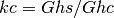
The real-sky irradiance/irradiation are calculated from clear-sky raster maps by the application of a factor parameterizing the attenuation of cloud cover. Examples of explicit calculations of this parameter can be found in Becker (2001), Kitler and Mikler (1986). However, the cloudiness observation by a meteorological service routine is usually prone to subjective errors and does not describe sufficiently the physical nature and dynamic spatial-temporal pattern of different types of cloud cover. Therefore, a simpler parameter has to be used. The solutions for horizontal and inclined surfaces are slightly different. For the assessment of global irradiance/irradiation on a horizontal surface under overcast conditions Gh the clear-sky values Ghc are multiplied by clear-sky index kc (Beyer et al 1996, Hammer et al 1998, Rigollier et al. 2001):

The index kc represents the atmospheric transmission expressed as a ratio between horizontal global radiation under overcast and clear-sky conditions. For a set of ground meteorological stations the clear-sky index can be calculated from measured global radiation Ghs and computed values of clear-sky global radiation Ghc:
As an alternative the kc can be derived also from other climatologic data (e.g. cloudiness, cf. Kasten and Czeplak 1980). The raster maps of kc must be then derived by spatial interpolation. The kc can be calculated directly as a raster map from short-wave surface irradiance measured by satellites. This method is based on the complementarity between the planetary albedo recorded by the radiometer and the surface radiant flux (Cano et al 1986, Beyer et al 1996, Hammer et al 1998). To compute the overcast global irradiance/irradiation for inclined surfaces, Gi the diffuse Dh and beam Bh components of overcast global radiation and of the clear-sky index kc have to be treated separately as follows from the following equations:
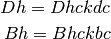
The ratio of diffuse to the global radiation Dh/Gh for clear and overcast skies changes according to the cloudiness. In Europe the Dh/Gh values are typically in interval 0.3-1.0 (Kasten and Czeplak 1980). The underlying physical processes are quite complicated and computationally represented only by empirical equations (cf. Scharmer and Greif, 2000, Kasten and Czeplak 1980, Hrvoľ 1991). However, for many meteorological stations, besides the global horizontal radiation Ghs, the diffuse component Dhs is either measured or calculated from cloudiness, sunshine or other climatologic data. The raster map of Dhs/Ghs can be derived from the point values by spatial interpolation. Consecutively, the raster maps of diffuse and beam components of the clear sky index can be computed:
where subscript s is meant to distinguish data measured on meteorological stations Bhs nd Dhs from the estimated values Bh, and Dh.
Temperature
Temperature is downscaled using a laps-rate which is fixed at 0.006 K m-1. The down-scaling is based on the difference in elevation between (1) the global low-resolution DEM belonging to the eartH2Observe dataset and (2) the local high resolution DEM. The down-scaled temperature is calculated for each grid cell of the high resolution DEM. Min and max temperature: Daily minimum and maximum temperature are calculated by taking the daily minimum and maximum
values from the 3-hourly temperature time-series.
Pressure
Pressure is down-scaled with the barometric formula. The barometric formula gives the pressure in the atmosphere as a function of height. Since temperature and the composition of the atmosphere are complicated functions of height, and because gravitation is an inverse function of the distance to the centre of the planet, three simplifications have been made within the version of the equation we apply:
- temperature, gravitation, and composition are assumed constant throughout the atmosphere;
- the atmosphere is assumed an ideal gas;
- temperature is assumed to decrease linearly with height with a slope L, the atmospheric lapse rate.
The downscaling is based on the difference (ΔH [m]) between the low resolution global and the high resolution local DEM according to the following equation:
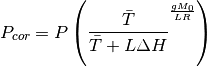
Where P = uncorrected pressure from the eartH2Observe dataset [Pa], $bar{T}$ = the daily average temperature from the eartH2Observe dataset [K], g = 9.81 - gravitational constant [m s-2], R = 8.3144621 - specific gas constant for dry air [J mol-1 K-1], Mo = 0.0289644 - molecular weight of gas [g / mol] and L = 0.006 - lapse rate [K m-1].
Evaporation methods
The following reference evaporation equations have been implemented:
- Hargreaves - temperature based
- Priestley-Taylor - temperature and radiation based
- Penman-Monteith – fully physically based
These are defined as follows:
Hargreaves:

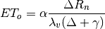
Priestley-Taylor:
Penman-Monteith (at z= 10m):
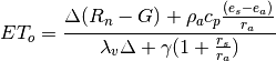
Where λv = Latent heat of vaporization (J/g), Δ = the slope of the saturation vapour pressure temperature relationship (Pa K-1), Rn = Net radiation (W m-2), G = Soil heat flux (W m-2), cp = specific heat of the air (J kg-1 K-1), ρa = mean air density at constant pressure (kg m-3), es - ea = vapor pressure deficit (Pa), rs = surface resistances (m s-1), ra = aerodynamic resistances (m s-1), γ = Psychrometric constant (66 Pa K-1), Ra = extraterrestrial radiation (MJ m-2 day-1), = mean daily temperature (°C), TR= temperature range (°C), α = empirical multiplier (-;1.26),
Implementation
ini file configuration
The .ini file below shows the available options
The file can be downloaded here: here.
Code description
-
e2o_dstools.e2o_calculateEvaporation.PenmanMonteith(lat, currentdate, relevantDataFields, Tmax, Tmin)¶ Parameters: - lat –
- currentdate –
- relevantDataFields –
- Tmax –
- Tmin –
Returns: relevantDataFields : [‘Temperature’,’DownwellingLongWaveRadiation’,’SurfaceAtmosphericPressure’, ‘NearSurfaceSpecificHumidity’,’SurfaceIncidentShortwaveRadiation’,’NearSurfaceWindSpeed’]
-
e2o_dstools.e2o_calculateEvaporation.PriestleyTaylor(lat, currentdate, relevantDataFields, Tmax, Tmin)¶ relevantDataFields : [‘Temperature’,’DownwellingLongWaveRadiation’,’SurfaceAtmosphericPressure’, ‘NearSurfaceSpecificHumidity’,’SurfaceIncidentShortwaveRadiation’,’NearSurfaceWindSpeed’]
-
e2o_dstools.e2o_calculateEvaporation.correctPres(relevantDataFields, Pressure, LapseRate, highResDEM, resLowResDEM, FillVal=1e+31)¶ Correction of air pressure for DEM based altitude correction based on barometric formula
Parameters: - relevantDataFields –
- Pressure –
- highResDEM –
- resLowResDEM –
Returns: corrected pressure
relevantDataFields : [‘Temperature’,’DownwellingLongWaveRadiation’,’SurfaceAtmosphericPressure’, ‘NearSurfaceSpecificHumidity’,’SurfaceIncidentShortwaveRadiation’,’NearSurfaceWindSpeed’]
-
e2o_dstools.e2o_calculateEvaporation.correctRsin(Rsin, currentdate, radiationCorDir, logger, missmask)¶ Corrects incoming radiation using the information from the e2o_radiation module
Parameters: - Rsin –
- currentdate –
- radiationCorDir –
- logger –
Returns: corrected incoming radiation
-
e2o_dstools.e2o_calculateEvaporation.correctRsinAlt(Rsin, AltitudeOrg, AltitudeDownscale, logger)¶ Corrects incoming radiation for DEM only
Parameters: - Rsin –
- AltitudeOrg –
- AltitudeDownscale –
- logger –
Return radcor:
-
e2o_dstools.e2o_calculateEvaporation.fixmapwithmask(data, mask)¶ Fill maps value within mask with average :param data: :param mask: :return: